Saint Francois Mountains
Contact
University of Arkansas Division of Agriculture
Cooperative Extension Service
2301 S. University Ave.
Little Rock, AR 72204

Saint Francois Mountains
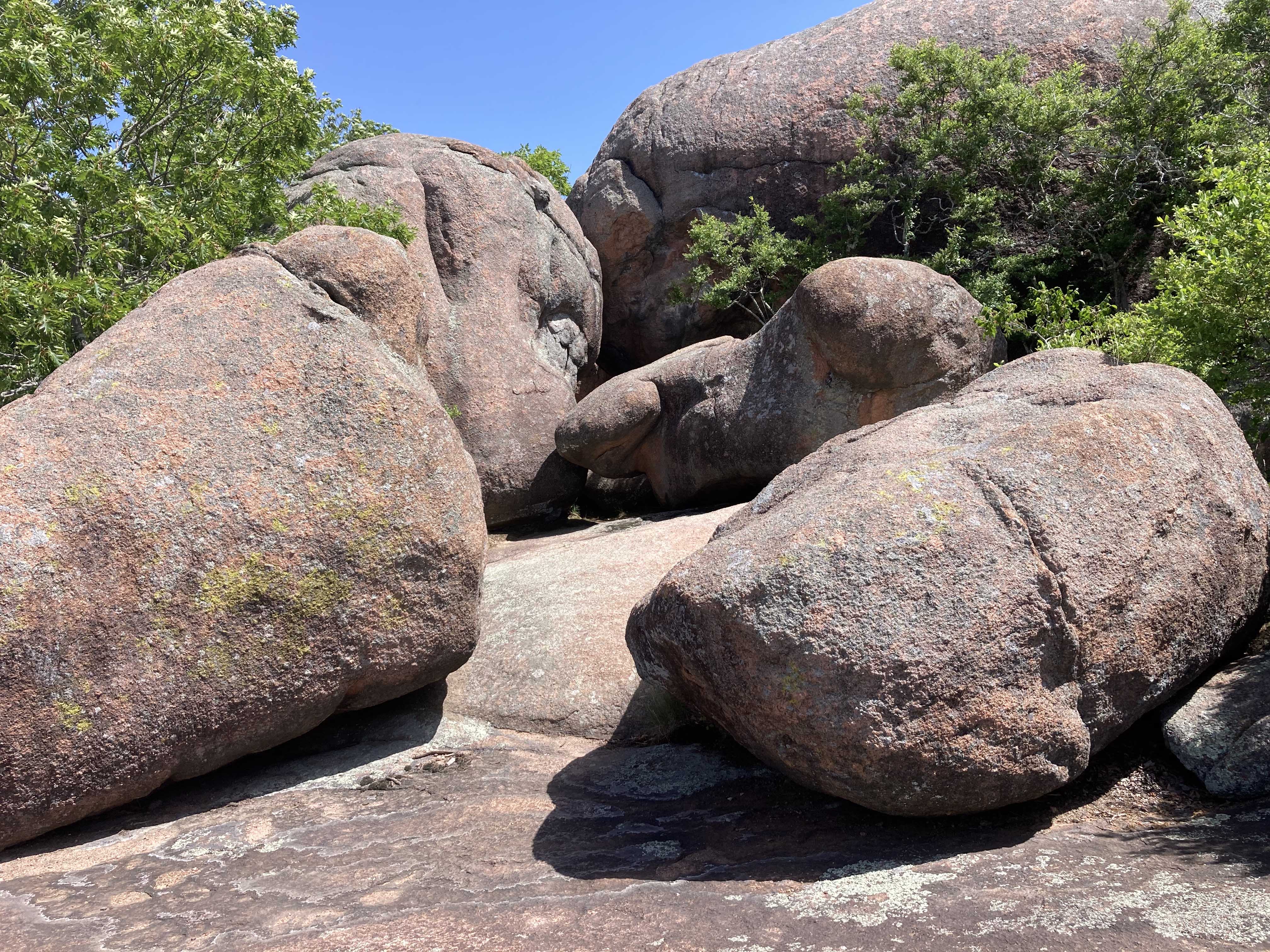
I love rocks. Last week while traveling across the Ozark Dome in southeastern Missouri I had the opportunity to explore the massive granite boulders piled in heaps at Elephant Rock State Park near the small town of Graniteville, Missouri. The story behind these rounded boulders, some as large as a house, requires a bit of time travel back when the earth was young and new mountain ranges like the Appalachians and the Rockies didn’t yet exist.
The granite now strewn about the surface there in Missouri ranges from almost 1.5 to 1.38 billion years old. As a point of reference, the earth is judged to be 4.5 billion years old, oldest life around hydrothermal vents first appeared about 3.5 billion years ago, oldest multicellular sea creature (a sponge) is 535 million years old, and, of considerable importance to Arkansans, the Ouachita Orogeny occurred between 320 to 300 million years ago. So, the formation of the Saint Francos Mountains occurred early in the development of North America.
There are two theories about how the old mountain chain formed. The most prevalent seems to be that there was a volcanic hot spot, similar to the one that is perking along in Yellowstone or the Big Island of Hawaii. The other possibility is that the volcanism was a result of continental plate collision, much as is occurring in the “ring of fire” surrounding the Pacific Rim. Though I’m hardly learned enough to have an opinion, I favor the second theory because of a geological feature called the “Spavinaw terrane.” This is an exposure of granite in Spavinaw, Oklahoma that has an identical composition and is the same age as the youngest granite rocks in Missouri. Bore samples from across northern Arkansas, western Missouri and Kansas show that the same granite underlies the sedimentary deposits found across the same area.
Igneous rocks form from molten magma. Literally, the mantle or lower crust melt and form a gelatinous pool or molten rock. If this happens close to the surface the molten rock can escape through cracks and form a caldera, the open maw of a volcano. In the case of the Saint Francos Mountains, at least four calderas have been identified, but there could be others that are covered in sediments.
The magma that found its way to the surface cooled quickly, forming hard, weather-resistant small-grain-sized rocks. A common one is called rhyolite, but others occur, depending on what minerals were being pumped up at any given time. The eruptions of these volcanos went on for about 100 million years, with several episodes of growth, then collapse of the caldera as the magma-filled chamber below emptied.
Eventually the volcanos went dormant and the molten rock in the magma chamber began to cool. But cooling takes a long time in this well-insulated subterranean world. The rock chemistry of the “extrusive” rocks that were squeezed out on the surface is the same as the “intrusive” rocks that cooled slowly below ground. But the intrusive rocks cool more slowly, so crystals of silica, potassium and whatever else happens to be there have more time to grow. The speckled look of the intrusive granite rocks, such as the large boulders at Elephant Rock State Park, is the result of the large grain size of these slowly cooled minerals. While these rocks were once buried deep in the heart of the mountain chain, the erosive forces over the past billion plus years wore the old mountain chain to a nubbin, leaving these remnants behind to ponder what might once have been.
When South America collided with the North American plate during the Pennsylvanian epoch, the Ouachita Mountains were pushed up and, further north, the Ozark dome lifted up but not so much to buckle and form a proper range of mountains. The deep hills and valleys we see today across the Ozarks is but surface erosion of a high place. Such is the fate of all high ground. It will eventually be flattened by time and weather, only to repeat the cycle time and time again.