Exploring the Buffalo
Contact
University of Arkansas Division of Agriculture
Cooperative Extension Service
2301 S. University Ave.
Little Rock, AR 72204

Exploring the Buffalo River
It really wasn’t my fault. I’d just seen Jeff Bridges' performance in Jack London’s classic Call of the Wild, a book I loved as a kid, when my son Joe asked if I wanted my own canoe for his annual Buffalo River float. With images of my handsome dog Winny sitting stoically in the bow while I paddled downstream, I pushed off with high expectations.
Perhaps I should have considered I had not been in a canoe in more than 20 years and that Winny neither saw the movie nor read the book, but things did not go well. The day before our trip the river was closed because of flooding, but by the next day it had dropped to “moderate” level. Too late I realized that meant “moderate flood level”, not moderate flow rate.
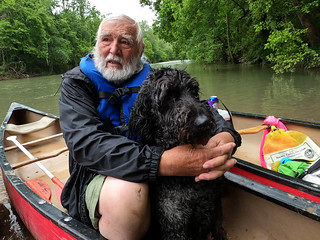
Within 100 yards of launch, we were in the drink, only partly because Winny was running hither and yon and extremely agitated. But, once committed to the river, you are pretty much in to the next landing. The next dunk was more frightening and I thought me, Winny and both sons might be drowned. But nothing tragic happened and I ended with a good story. But my desire to explore the length of the river by canoe was squelched. Instead, I’ve decided to explore the river in my camper van.
In an effort to understand the terminology involved in “government speak”, I find that the 1968 Wild and Scenic River Act designated eight rivers around the nation as such but the Buffalo River was not amongst them. Today, there are 209 rivers that bear the wild and scenic designation. But only four “national” rivers and 10 of the wild and scenic rivers are administered by the National Park Service. In 1972, due to the efforts of Dr. Neil Compton and Ozark Society, the Buffalo River was the first national river added to the properties managed by the National Park Service. The other wild and scenic rivers are administered by a variety of federal, state and local agencies.
Interestingly, one of the four national rivers — West Virginia’s New River Gorge National River, so designated in 1978 – was changed from the national river status to national park status in 2021. In the change of status, less than 10 percent of the land protected in the national river made it into the new National Park. The rest of the land is now in a “national preserve” where Congress decided that extraction of certain natural resources — such as through farming, logging, mining or drilling — is now permitted. Currently, there are 21 of these national preserves around the country. This aside is of interest to me because there seems to be a movement afoot to change the status of the Buffalo National River to national park status.
The Buffalo National River is 135 miles long and runs from west to east through Newton, Searcy and Marion counties and into Baxter County where it dumps into the White River at Buffalo. The upper shallow end of the river, 18 miles, starts in the Boston Mountains near Red Star and is designated as a Wild and Scenic River and managed as a part of the Ozark National Forest. The river course cuts through the three geologic zones of the Ozark dome, the Boston Mountains, the rich Springfield Plateau, and into the Salem Plateau.
Visitation is now said to be around two million per year but I don’t expect to see too many people as I prowl the back roads around the river. I’ve always found wintertime to be a fine time to drive Arkansas back roads because, with the leaves gone, you can actually see the sights.
Stay tuned.
Over the next few weeks, I plan on driving east along the north side of the river and then returning west along the south side just to see what I can see.