Boxley Valley and the Upper Buffalo
Contact
University of Arkansas Division of Agriculture
Cooperative Extension Service
2301 S. University Ave.
Little Rock, AR 72204

Boxley Valley and the Upper Buffalo
As a prowler of Arkansas backroads, I’ve always loved the meandering 225-mile-long Arkansas 16 that begins in Siloam Springs and heads east across the Ozark Plateau, eventually ending in Searcy. This was one of the first federally funded highways in Arkansas and dates from the 1926 highway bill, but I drove it through the woods in Van Buren County in the 1980s when it was still a dirt road. Today it is all paved, but don’t think of it as a shortcut because it is a narrow, twisting road. It has a place in our story about the Buffalo River because it mostly follows — at least the 100 miles from Boston to Clinton — the high ground separating the White River drainage from the Arkansas River watershed.
With elevations above 2,100 feet, the 15-mile stretch of Arkansas 16 from Boston to Fallsville is some of the highest terrain in the Boston Mountains. From this high ground is spawned three of Arkansas’ eight Wild and Scenic Rivers: the Buffalo National River, which starts about a mile east of Red Star, the Big Piney Creek just south and to the east of Fallsville and the Mulberry River just south and west of Fallsville. But, not done yet, the White River begins its 700-mile journey to the Mississippi River from Boston. In the seven miles between Boston and Red Star and on the north side of the road the scenic War Eagle Creek and Kings River both start their flow to the White River. For much of this section, AR 16 runs along a hogback separating the White River drainage to the north with the Arkansas River watershed to the south.
The upper part of the river is in the aptly named Upper Buffalo Wilderness Area managed by the U.S. Forestry Service. The river drops more than 1,000 feet over about 20 miles and is only accessible by some strenuous hiking trails and those fool hearty enough to attempt kayaking it during periods of high water. The seven-mile-long Boxley Valley, with an elevation of about 1,100 feet and encompassing about 5 percent of the land area of the National River, is a living landscape that showcases Ozark life during the 19th century.
When the National River designation was given to the National Park Service, a development plan was advanced that would allow private holdings within the parkland boundaries, recognizing that settlement was part of the story to be told by the park. But this was not in the DNA of the park service, whose “we control everything” approach resulted in an attempt to buy up all private land holdings. Within a decade, it was recognized the bulldozer approach was not working, and a new plan was developed that allowed residents to remain in the valley and continue pre-park practices with some restrictions. The beautifully preserved and maintained 19th century homes and churches found in Boxley Valley today are a product of this second land use plan and make for a richer visitor experience than simply allowing this rich bottomland to return to the wild. Fifty years later, resentment still festers amongst some about government overreach, but most long-term residents have accepted the new arrangement and view the possible changes proposed last fall with suspicion.
One of the gems of Boxley Valley is the two-hour hike up Lost Valley to Eden Falls, the natural bridge, Cob Cave and the true cave with a waterfall inside. Governor Orval Faubus, during the last weeks of his term in 1966, bought 200 acres of land in the valley to establish a state park, but in a political sleight of hand, purchased the 80 acres with the falls and the caves personally. When this made the front page of the Arkansas Gazette six months later, he quietly sold the land to Little Rock friends who donated the land to the new state park. Another excellent hike in this area is the Buffalo River Trail from Ponca to Steel Creek, about three and a half miles round trip.
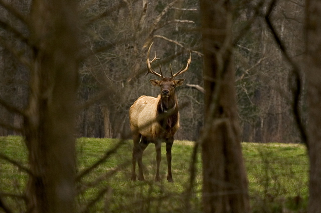
And then there are the elk. In the early 1980s the Arkansas Game and Fish Commission, working with the National Park system and a group in Colorado reintroduced elk to the Buffalo Valley. Elk had been hunted to extinction by 1840, so the reintroduction was a big success. The annual survey conducted in March 2023 spotted 419 animals that range throughout the watershed and into adjacent drainages. Hunting has been permitted since 1988 but only 18 permits were issued in 2023 with them being made available by a lottery system. The elk can be seen in the pastures near Ponca in the early morning hours and later in the day from late September through March.
The Boxley Valley is the part of the Buffalo River country I know best because Ponca was where I set out on the couple of canoe trips I made on the river as a younger man. Mile for mile it has some beautiful scenery, but I look forward to getting to know the rest of the river better.