Contact
Mike Daniels, PhD
Professor of Environmental
Quality and Nutrient Mgt
UACES
2301 S. University Avenue
Rm 307F
Little Rock, AR 72204-4940
Fax: 501-671-2297
Email: mdaniels@uada.edu
Water Quality Resources

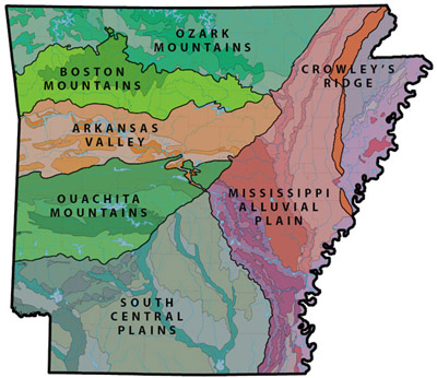
Specific standards are set for each of the EPA's seven ecoregions of Arkansas. [Image courtesy of Ecological Design Group]
Each of the designated uses for water - drinking, recreation, agriculture, etc. - has different defined chemical, physical and biological standards necessary to support that use. For example, we expect higher standards for water we drink and swim in compared to that used in agriculture and industry.
Water Quality standards include criteria for minerals, bacteria, clarity, temperature, oil and grease, acidity or alkalinity, dissolved oxygen, nutrients, and toxic substances to name a few. The federal Clean Water Act requires each state to develop standards to protect its lakes, reservoirs, rivers, streams, creeks, and ditches.
The Arkansas Pollution Control and Ecology Commission (APCEC) is the environmental policy-making body for Arkansas. With guidance from the Governor, the Legislature, the EPA and others, the Commission determines the Water Quality standards for the state and the Arkansas Department of Environmental Quality (ADEQ) implements those standards.
Download our fact sheet -What is Water Quality?
Watershed Information
ARExtension YouTube | What is a Watershed? by John Pennington
| AG1290 | Arkansas Watershed Steward Handbook |
| FSA9521 | Arkansas Watersheds (color) - importance of watersheds, explanation of the Hydrologic Unit Code (HUC). |
| FSA9526 | Using the Watershed Approach to Maintain and Enhance Water Quality - watersheds, stakeholders, and the watershed approach |
| FSPPC112 | The Role of Nonpoint Source Models in Watershed Management - types of nonpoint source models, uncertainty, and challenges to prioritizing watersheds |
| FSPPC116 | Watershed Prioritization for Managing Nonpoint Source Pollution in Arkansas |

-
Arkansas Watershed Map
View watershed and surface water boundaries, and add or subtract various layers of data including roads, drainage ditches, natural and scenic rivers, and more. -
Surf Your Watershed
Locate involved organizations, websites, health assessments, and water quality monitoring data about a particular watershed.
Drinking Water
 Most likely your drinking water comes from some type of surface reservoir or well.
You may also wonder whether or not your drinking water is safe. Municipalities generally release annual water quality reports that describe what is present in the water and in what quantities.
Wastewater treatment facilities receive the water that you put down the drain. Once there, the wastewater undergoes effective cleaning and purification techniques that remove contaminants and make the water safe to consume once again.
Arkansas Water and Wastewater Systems
- Central Arkansas Water - Little Rock
- Beaver Water District - Beaver Lake, Northwest Arkansas
- Fayetteville Wastewater Treatment Facilities
- Little Rock Wastewater
- Arkansas Rural Water Association
- ADH Private Water Testing– Arkansas Department of Health's description on testing parameters within the Water
Microbiology Lab, including instructions for water sample testing submissions.
- ADH Community Water Fluoridation Program– Includes a description of this ADH program and several resources for learning more
about fluoridation
- Cyanobacterial Harmful Algal Blooms (CyanoHABs)– EPA's informational website on CyanoHABs, including definition, detection, effects,
research, causes, prevention, mitigation, and policies.
- SRWP Drinking Water FAQs– A database of Frequently Asked Questions related to Drinking Water and Human Health, developed by the Alabama partnership of the Southern Regional Water Program.
Water Quality Assessment
- ADEQ Surface Water Quality Monitoring Data Search Page – Searchable database to view water quality data from over 160 stations across the
state over the past 22 years. If you don't know which stations to look for, you can
search to view all stations within a county.
- ADEQ Water Quality Standards Review – The federal government requires that each state review its Standards every three years to study how water is used and to consider whether limits on pollutants should be tightened. Water Quality Standards are essentially numerical limits on pollutants which affect how we use water. The Standards include limitations on minerals, bacteria, clarity, temperature, oiliness, acidity or alkalinity, oxygen, nutrients and toxic substances.
- Groundwater Watch: Arkansas - The Active Groundwater Level Network contains water levels and well information
from more than 20,000 wells that have been measured by the USGS or USGS cooperators
at least once within the past 13 months. This network includes all of these wells,
regardless of measurement frequency, aquifer monitored, or the monitoring objective.
- National Water Information System: Mapper – A mapping tool that allows you to view surface water, groundwater, spring, atmospheric,
and other monitoring sites. The data is clickable when zoomed to level 11 or greater.
- WaterWatch: Flow – Displays maps, graphs, and tables describing real-time, recent, and past streamflow
conditions for the United States. The real-time information generally is updated on
an hourly basis.
- Water Quality Watch – Displays real-time water quality parameters for the nation or on a state level,
including temperature, specific conductance, pH, dissolved oxygen, turbidity, nitrate,
and discharge.
- USGS Water Quality Data – Choose between real-time or daily data, then select Arkansas (as "station name"
in real-time, or the "site location" check box in daily) and check the parameters
you would like to view (in daily data only).
- Current Conditions for Arkansas: Streamflow – A table of the USGS Gage Stations in Arkansas and the current streamflow levels.
