
Arkansas Board of Apportionment
The board sets Arkansas districts for state Senate and House members. Now updated for 2021.
Look back at 2011 process Arkansas lawmakers represent residents and businesses at the state and national level.
Who they represent depends on where the lawmaker lives and the boundary lines drawn
every 10 years to divide Arkansas into legislative districts.
Arkansas lawmakers represent residents and businesses at the state and national level.
Who they represent depends on where the lawmaker lives and the boundary lines drawn
every 10 years to divide Arkansas into legislative districts.
States review legislative districts after the end of every U.S. Census to see if changes to boundary lines are needed. This once-a-decade review process starting in 2021 is called “redistricting.” Boundaries often move to reflect how an area’s population has changed. The more people in an area, the smaller the district may be. The fewer people, the larger the district may be.
A similar process takes place for quorum courts, city councils/boards, school districts and community college boards in Arkansas.
Need a handout to explain the process? Download or print off our fact sheet below: Citizenship in Action: How the Redistricting Process Works in Arkansas.
Download Our Redistricting Fact Sheet
 Constitutional amendments approved by voters in 1936 and 1956 guide who is responsible
for establishing new election districts for state and federal lawmakers after the
census.
Constitutional amendments approved by voters in 1936 and 1956 guide who is responsible
for establishing new election districts for state and federal lawmakers after the
census.
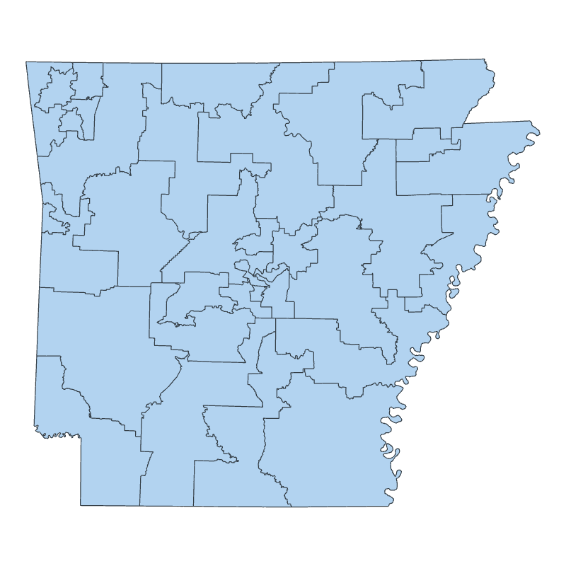
State Districts - Arkansas’ governor, secretary of state and attorney general are responsible for drawing boundaries for the 100 House of Representative districts and 35 Senate districts in the state. The three officials meet as the “Board of Apportionment” the year after each federal census to determine districts.
The total number of state legislators always remains the same, but the communities and residents in districts that legislators represent may change depending on the maps created and adopted by the Board of Apportionment.
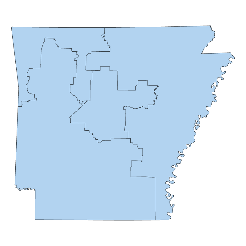
Congressional Districts - State senators and representatives are responsible for drawing the boundaries for U.S. House of Representatives districts in Arkansas. (No one draws boundaries for U.S. Senate districts because Arkansas’ two senators represent the entire state.)
The United States has 435 representatives. This number doesn’t change, but the number of representatives per state can depending on nationwide population changes. The process for determining the number of congressional representatives is called “apportionment.”
Arkansas has four U.S. House of Representatives seats and is expected to keep that number after the 2020 Census, though how districts within the state are drawn will change during the redistricting process.
The Committee on State Agencies and Governmental Affairs in the Arkansas House and Senate have oversight of the redistricting process.
State Districts - The Arkansas Board of Apportionment approved new maps for the Senate and House on Nov. 29, 2021. The maps were expected to go into effect Dec. 30, 2021 if there were no legal challenges.
Two Arkansas organizations filed a lawsuit Dec. 29, 2021 against the Board of Apportionment challenging the new map of House of Representatives districts. A federal judge dismissed the lawsuit in February 2022, but plaintiffs appealed to a higher court with hearings continuing into 2023.
Congressional Districts - State legislators on Oct. 7, 2021 approved new maps for the four U.S. House of Representatives districts in Arkansas. The Senate and House passed identical maps, which are expected to go into effect mid-January if there are no legal challenges. A ballot issue group has filed paperwork with the Secretary of State's Office for a voter referendum on the new districts. The group has until January to turn in nearly 54,000 voter signatures to qualify their issue for the November 2022 ballot.
Read Acts 1114 and 1116 that describe the new boundaries for U.S. House of Representatives in Arkansas.
Redistricting at the local level in Arkansas typically involves three levels of local government.
Quorum Court - Every county in Arkansas has a three-member election commission whose duties include overseeing elections as well as deciding the boundaries of representation at the county level after each federal census. Election commissions propose and adopt county maps showing the boundaries of each Justice of the Peace district. Justices of the Peace serve on the Quorum Court.
City Council or City Board -In cities where voters elect their city council or city board member by ward, the council or board sets the ward boundaries. In smaller cities where voters elect their representatives city wide, there are no ward boundaries.
This is the first redistricting effort where city directors have an official say in redrawing boundaries in communities using the city manager/administrator form of government. Previously, election commissions were responsible for approving maps for board of directors. Act 314 of 2013 removed the election commission from the redistricting process.
School Board - In school districts where voters elect their school board members by zone, the boundaries for the zones are determined by the school board. The election commission also votes to adopt the map. In smaller school districts where voters elect their board member district wide, there are no school board zone boundaries.)
Learn more about redistricting at the local level in Arkansas by watching this Sept. 29, 2021 panel discussion with Fort Smith Mayor George McGill, Mena Mayor Seth Smith, and Jennifer Price, director of elections in Washington County. Emily Smith of the Community, Professional and Economic Development unit at the Cooperative Extension Service, along with Kristin Higgins of the Public Policy Center, hosted the webinar.
Arkansas’ Constitution requires new maps to be adopted the year after the census. Because of the pandemic in 2020 and other delays, the release of census information was delayed until this fall. City, county and state officials will have less time than previous decades to complete the task.
State Maps – Gov. Asa Hutchinson, Secretary of State John Thurston and Attorney General Leslie Rutledge began meeting as the Board of Apportionment on May 24, 2021. They hired Betty Dickey, a former Arkansas Supreme Court chief justice, as the state's redistricting coordinator to help gather public comments and oversee the process of creating new boundaries.
Federal maps – The Arkansas General Assembly resumed meeting Sept. 29 in part to complete their task of adopting new boundaries for the state's four U.S. House of Representatives seats. Lawmakers filed 33 proposed maps. They voted Oct. 7 on a final map to send to the governor.
The Committee on State Agencies and Governmental Affairs in the House and Senate have oversight of the redistricting process.
Local maps – Quorum Courts, city councils and boards, and school district boards are discussing right now how to readjust boundaries for representation based on new census data. Look below for links to find your election commission, cities and school boards.
The Board of Apportionment hosted a series of eight public meetings across Arkansas this summer. You can access recordings of the meetings on the Arkansas Board of Apportionment Events Calendar You can also read comments people submitted to the board about redistricting on the Public Comments page
For congressional districts, legislators have voted on the final maps. Several members of the public spoke for or against the proposed maps at committee meetings.
At the local level, now is the time to find out when your county election commissions, city councils and school boards will be discussing changes to their districts, wards and zones. These meetings are open to the public.
The board sets Arkansas districts for state Senate and House members. Now updated for 2021.
Look back at 2011 process
Follow the committee online.
Follow the committee online.

Many cities post public meeting notices online. Councils are in charge of drawing their own election boundaries

Many school districts post public meeting information for their school boards online.

"One person, one vote" is one of several criteria used when updating district maps
for lawmakers.
The Secretary of State's website hosts current district maps for state lawmakers and U.S. House of Reps.

Want to try your own hand at redistricting? Districtr is a free online simulation tool.

County Election Commissions are responsible for drawing voting districts for justices of the peace.
Want to see how Arkansas' congressional districts have changed over time? The Arkansas Geographic Information Office recently published a series of interactive maps that allow you to see how districts have changed over time since the 1940s. Clicking on the map will allow you to see the county and district population for each decade.
Arkansas started in 1840 with one congressional representative. That number grew to a high of seven by 1900. 1940 was the last year Arkansas had seven districts, with roughly 278,484 people per district. After the 1950 Census, Arkansas lost a seat. The 1960 Census brought another loss as other states grew in population. The state lost two more seats, leaving us with the same four seats we have today.
In 2010, according to the website, the decade marked the first time congressional districts split counties. The counties that fall into two congressional districts include: Crawford, Jefferson, Newton, Searcy and Sebastian counties. The target population for congressional districts at that time was 728,980 people, though some fell just above and below that target.
During the last redistricting process in 2011, the board of apportionment held its organizational meeting in March to start work on state-level districts. Their last meeting took place in July, with approval of the final Arkansas maps. The maps took effect 30 days after their filing with the Secretary of State. Transcripts of these past meetings can be accessed through an internet archive of arkansasredistricting.org/documents at https://web.archive.org/web/20210113143039/https://arkansasredistricting.org/documents/.
NCSL helps prepare legislatures and others for the redistricting cycle with comprehensive information on redistricting law, technology and process.
iCivics offers an online game for students to learn about redistricting and gerrymandering.