Posts
Contact
Kristin Higgins
Public Policy Center
Phone: 501-671-2160
Email: khiggins@uada.edu
University of Arkansas Division of Agriculture
Cooperative Extension Service
2301 S. University Avenue
Little Rock, AR 72204
Upcoming Public Hearing Latest Step in Arkansas Lithium Mining Journey
Southwest Arkansas sits on top of five to 19 million tons of lithium reserves, according to a U.S. Geological Survey study recently released calculating the potential amount of the mineral present in Arkansas.
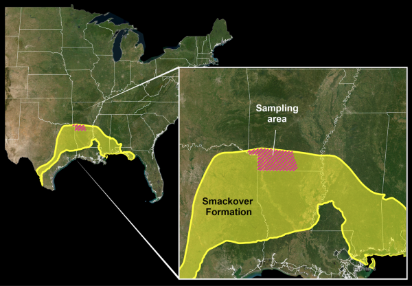
As of today, commercial-scale lithium mining takes place only in Nevada and Utah. Communities in Columbia, Lafayette, Miller and Union counties in Arkansas are part of the Smackover Formation, a relic of ancient sea that left limestone and deposits of oil and bromine. The formation crosses state lines also into Alabama, Florida, Louisiana, Mississippi and Texas.
Companies interested in mining lithium and owners of land and mineral rights in the region are still negotiating royalties, or payments, for extracting mineral-laced brine from underground.
Public Hearing in May
Successfully extracting lithium from the Smackover Formation and processing the mineral into power sources (think lithium batteries) could have a significant impact on the economy in southwest Arkansas.
Initially some of the impact would come in the form of royalties, or payments to mineral rights owners in return for extracting lithium-infused brine. (The mineral right owners could be the property owners or companies that have purchased mineral rights previously from the property owners).
The Arkansas Oil and Gas Commission will host a public hearing at 9 a.m. on May 28 in Magnolia on the Southern Arkansas University campus to discuss royalty rates proposed in a recent application. The hearing will take place in the Donald W. Reynolds Campus and Community Center Grand Hall, 100 E. University. The nine-member commission, established in 1939, regulates the state's oil and natural gas industry.
Establishing a payment rate for lithium in Arkansas will remove a policy roadblock that’s stalled the extraction process.
Smackover Lithium Ltd., a joint venture of Smackover Lithium of Canada and Equinor of Norway, has proposed a 2.5% royalty payment rate in Arkansas. According to Arkansas Business, “Standard has been producing battery-grade lithium products in Arkansas for more than three years, but no Arkansas-sourced lithium can be sold before the commission sets a “fair and equitable” royalty to compensate landowners with lithium brine beneath their acres.”
The Arkansas Oil and Gas Commission rejected a previous royalty rate proposal of 1.82% in November 2024. One organization representing landowners, South Arkansas Minerals Association, had requested a royalty rate similar to what exists for oil and gas or 12.5%, which companies said was too high.
Arkansas Business reported that royalty fees are in addition to “brine fees,” or “in lieu bromine royalty,” which is $65.05 per acre per year.
What exactly is Lithium?
Lithium is a metal-or #3 on the periodic table.
According to Erik Pollock, a University of Arkansas geologist, “most of the time when we think about lithium in our batteries, we’re thinking about lithium carbonate or lithium phosphates.”
Listen to the University of Arkansas podcast featuring Pollock
But in the Smackover Formation, lithium is found in the salty brine water below ground. There are natural passageways making it easier for companies to extract the brine, Pollock said. The missing pieces of infrastructure in Arkansas are facilities to process the brine and repackage the lithium into a usable form. Arkansas’ lithium potential is “technology heavy,” Pollock said.
At the moment, lithium in brine is considered a waste stream because it’s often co-produced during oil and gas production, according to the USGS report.
Where is Lithium found in Arkansas?
Lafayette County
- Population estimate (2024): 6,015
- Per capita income (2023): $22,393
- In March 2025, the unemployment rate for Lafayette County was 4.8%, according to the Federal Reserve Bank of St. Louis.
- The largest employer in the county is the Lafayette County School District.
Columbia County
- Population estimate (2024): 22,024
- Per capita income (2023): $25,947
- In March 2025, the unemployment rate for Columbia County was 4%, according to the Federal Reserve Bank of St. Louis.
- The largest employer in the county is Southern Arkansas University.
Miller County
- Population estimate (2024): 41,958
- Per capita income (2023): $28,025
- In March 2025, the unemployment rate for Miller County was 4.3%, according to the Federal Reserve Bank of St. Louis.
- The largest employer in the county is Cooper Tire and Rubber Co.
Union County
- Population estimate (2024): 37,008
- Per capita income (2023): $30,968
- In March 2025, the unemployment rate for Union County was 5%, according to the Federal Reserve Bank of St. Louis.
- The largest employer in the county is Murphy Oil, USA.
How would lithium be extracted in Arkansas?
Lithium is expected to be mined differently in Arkansas than other substances and how companies produce it in other countries. The Smackover Formation is 8,000 to 10,000 feet deep.
Production and injection wells will help producers bring brine to the surface, where the lithium would be removed. According to the Arkansas Department of Energy and Environment, the brine would be re-injected into the same area. Pollock, and ADEE, reiterated that extracting lithium would not involve “strip mining,” open pits, or evaporation ponds as seen in other locations.
Instead, there will be pipes and buildings, Pollock said.
Additional Resources
Lithium in Arkansas – A Quick Overview
Sources:
Arkansas Economic Development Commission:
Federal Reserve Bank of St. Louis: https://fred.stlouisfed.org/series/ARUNURN
U.S. Census Quick Facts: https://www.census.gov/quickfacts/
U.S. Geological Survey:
USGS Photo caption: This map of the U.S. shows an inset area displaying highlighted areas for the Smackover Formation and sampling area. The Smackover formation (highlighted in yellow) covers the southern to eastern portion of Texas, southern portion of Arkansas, the upper half of Louisiana and some eastern areas, southern half of Mississippi, southwest area of Alabama, and portions of the Florida panhandle. The sampling area is located in the lower portion of Arkansas (highlighted with red stripes).