Resource Library
Plant of the Week: Plant Hardiness Zone Map, USDA
The University of Arkansas System Division of Agriculture does not promote, support or recommend plants featured in "Plant of the Week." Please consult your local Extension office for plants suitable for your region.
Plant of the Week
Last updated: 2012
Read our news story for info on the 2023 hardiness zone map update.
New USDA Plant-Hardiness Zone Map
Gardeners rely heavily on plant-care tags affixed to the plants they buy. One of the items listed on each plant care tag is the hardiness zone. The USDA-ARS, with the help of climate scientists at Oregon State University, has just released a new plant-hardiness map, updating its 1990 Plant Hardiness Zone Map to bring it into conformity with the warming trends that are becoming so apparent to gardeners. Though Arkansans are not quite in the banana belt, we are getting closer.
The first hardiness zone map was published in Alfred Rehder’s 1927 book Manual of Cultivated Trees and Shrubs. Rehder and Donald Wyman, who took up his work at Boston’s Arnold Arboretum, didn’t have the reach of the USDA, which published its first Hardiness Zone Map in 1965, which soon became the standard for the nation.
All of these maps have used average minimum temperatures as demarcations, with 10ºF differences separating the zones. Those first zone maps were generalized representations painted across a map; however, each new iteration became more accurate and sophisticated as better data sets became available.
What does the "A" and "B" section of each zone mean?
The coldest zone is Zone 1, with a minimum winter temperature of -60ºF; the warmest is Zone 13, with a minimum winter temperature of 70ºF. Each zone is divided into an A and B section, with B 5 degrees warmer than A. The 2012 map is the most accurate to date, and the first designed for the computer age. Google “Plant Hardiness Zone Map” and you will find a site that will allow you to download state, regional or national maps.
What's different about the new hardiness zone map?
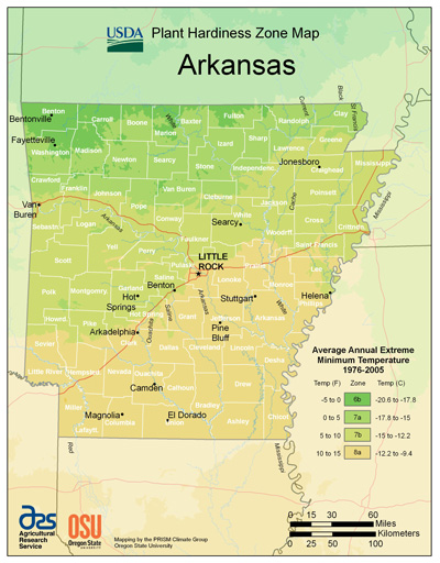
In general, the new hardiness zone map shows each zone boundary has pushed north about two-and-a-half degrees of latitude (about 175 miles), though elevation and microclimate conditions sometimes obscure these changes. Here in northwest Arkansas, for example, zone 6b has receded like a melting glacier, remaining only in higher elevation parts of seven counties. Zone 7 dominates most of the land area of Arkansas, with areas north of I-30, east of Little Rock and everything north of I-40 falling in that zone. Zone 8a has pushed out of the gulf coastal plain region and now reaches north all the way to Little Rock.
The data set used to compile the new map was accumulated from 14,500 weather stations, spanning the years of 1976 until 2005. A proposed 2005 zone map revision, which used data from 1990 through 2005, was killed because this shortened time span radically pushed zones north and clearly showed the effects of global warming. The 2012 map is both a political and biological compromise, but does a better job of identifying plant hardiness limits than the 1990 map.
Hardiness zone maps are a good shorthand method for approximating where plants will grow, but they need to be taken with a grain of salt. For the most part, the simple and easy-to-use USDA map does a good job of identifying both the northern and southern limits of where a plant will grow.
But, of course, gardening is not about broad strokes on the map, but about specific microclimate in a particular garden. The south side of your house might well have enough extra protection to make that one small bed suitable for zone 8 plants, when the rest of the garden is confined to zone 7 as shown on the map.
The winter of 2011 was a cold and snowy here in Fayetteville, and shows how this works in practice. The Botanical Garden of the Ozarks recorded -22º on Feb. 12, the coldest temperature ever recorded here. As a result of this extreme event, all of our broadleaf evergreens, all of our crape myrtles and a number of native and exotic shrubs froze to the ground. We lost all flower buds on dogwoods, redbuds, cherries and all of our deciduous flowering plants, except crabapples and deciduous magnolias. Yet, about five miles away and 250 feet higher, my garden escaped unscathed, with the temperature minimum only dropping to -6ºF. In this instance, the cold air sank to the valleys, and higher elevation sites were spared.
By: Gerald Klingaman, retired
Retired Extension Horticulturist - Ornamentals
Extension News - February 17, 2012
The University of Arkansas Division of Agriculture does not maintain lists of retail outlets where these plants can be purchased. Please check your local nursery or other retail outlets to ask about the availability of these plants for your growing area.